


For the second year in a row, two children of the Brink family, recently relocated to Grimsby, Ont., from Brampton, are among winners of the Legion’s annual poster and literary contests.
Ten-year-old Joseph Brink and his brother William, seven, placed first in the junior and primary black and white poster competitions respectively. In 2014, their sister Anneke Joy’s junior colour poster placed first and brother James Theodore placed second in the primary black and white poster competition.
Approximately 100,000 students participate in the Legion’s annual literary and poster contests, and competition is stiff. Entries progress from the local through the provincial to the national level, where they are judged by a panel which considers originality, expression, presentation and grammar and spelling. The contests have two divisions: poetry and essay in the literary contests, colour and black and white in the poster contests. Awards are made in the senior (Grades 10-12), intermediate (Grades 7-9), junior (Grades 4-6) and primary (kindergarten through Grade 3) categories.
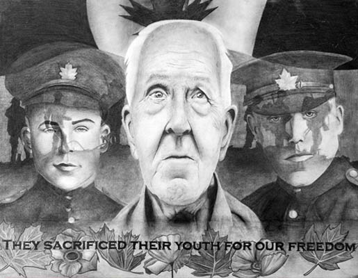
Joseph Brink’s poster features a soldier, hands covering his face, backed by a tank firing in the darkness. Lacking a family member with military experience, his inspiration was a Bible verse from John 15:13: “Greater love hath no man than this: that a man lay down his life for his friends.”
Honouring those who died is important, he said, because “they gave their lives for us.”
On a 2014 pilgrimage to Juno Beach, where more than 350 Canadian soldiers gave their lives on D-Day in 1944, Victoria Fisher, of Minnedosa, Man., was momentarily angered by the sound of children playing on the “hallowed ground.” Her first-place senior essay, “Boys in the Sand,” explores conflicting emotions roused by remembrance.
“At first I feel a prick of anger,” she writes, then “I’m hit with a wave of thankfulness.” She reflects on her reaction; she and the French children were growing up in peace, not experiencing death and oppression.
The essay concludes: “I grieve for those who came before me and gave everything…I also feel joy and gratefulness…. I only hope that if my time comes to take a stand that I can do it too, for those like the boys in the sand.”
“We are taught remembrance in moments of silence,” but she has learned silence is not necessary to celebrate peace, said Fisher, an air cadet spending the summer at a survival instructors’ course in Cold Lake, Alta., the home of 4 Wing. Aside from the new-found insight into emotions, Fisher comes away with a new-found confidence in her voice as a writer. “I never thought before I entered the contest that I could make other people feel the same way I did.” And then “a teacher thanked me” after reading the piece, which began life as an essay in a school English exam.
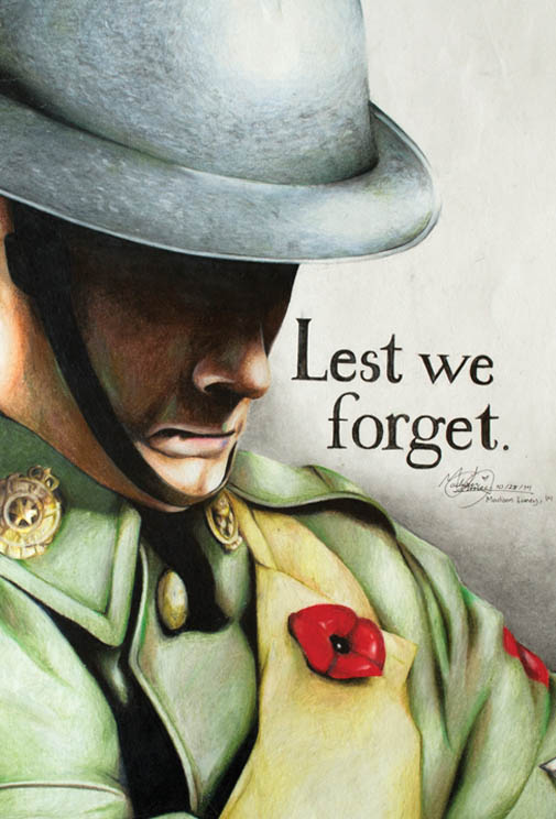
Life experiences have also forged Sideqa Haqani’s perspective on remembrance. The winner of the senior black and white poster competition is the daughter of immigrants who came to Canada from Afghanistan 22 years ago and now live in Gloucester, Ont. Two of the family’s seven children were born in Afghanistan, the remainder in Canada.
“I grieve for those who came before me and gave everything…I also feel joy and gratefulness…. I only hope that if my time comes to take a stand that I can do it too, for those like the boys in the sand.”
“I am so lucky to be living in a country where there is peace,” she said. “And proud to live in a country which helps provide peace elsewhere.”
Her poster features an elderly veteran backed by images of two soldiers in historic uniforms, across whose faces trails a band of ghostly images. Although the poster harkens to times past, “sacrifices continue to be made,” she said. “It’s a huge accomplishment for someone to find the courage…to go overseas and fight in a country they’re not even affiliated with.”
The Legion sponsors the winners of the four senior categories to come to Ottawa to attend the national Remembrance Day ceremony, where they place a wreath on behalf of the youth of Canada and meet the governor general. They also tour the Parliament Buildings, including the Memorial Chamber in the Peace Tower, and the Canadian War Museum.
Winning senior poster by Sideqa Haqani of Gloucester, Ont.
Winning senior poster by Natasha Jones of North Vancouver, B.C.
Although senior colour poster winner Natasha Jones, of North Vancouver, B.C., has visited Ottawa once before with family, “I’m looking forward to having a more in-depth look this time. It’s a chance to look at the whole history” of Canada’s military.
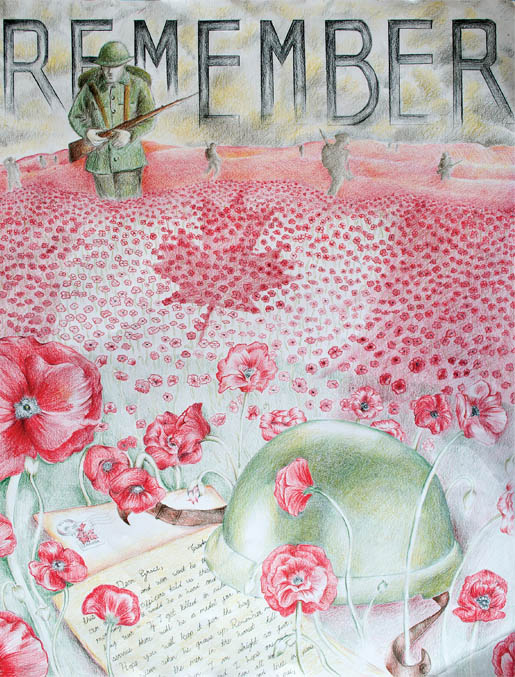
Remembrance is a duty, she said, but it shouldn’t stop at one day a year. She fulfills her duty by appreciating the personal stories behind that history. This is reflected in her award-winning senior colour poster, where a letter from a soldier to a loved one at home is anchored by a helmet and backed by a field in which poppies make up the red of the Canadian flag.
“A lot of people think it all happened before,” she said, “but it still goes on.” It’s important for young people to know the stories of those who served and perhaps died in the past, but also of those serving today.
Chance Michael Fiessel of Sturgeon County, Alta., tells in his second-place senior essay of his argument with teachers, who said “we shouldn’t worry about our current soldiers because they are still alive…. Of course, no one has ever seen it the way I did.”
His father is an Afghanistan veteran who had many close calls and is marked forever by his service. He narrowly missed injury when a rocket struck the vehicle he had just been beside. Another time a close friend, who
had taken a position on tour “so my father wouldn’t have to go again so soon,” stepped on an improvised explosive device and was killed. “I know my father still carries guilt for this.
Winning intermediate poster by Madison Luney of Burnaby, B.C.
Winning intermediate poster by Caitlyn Mei of Richmond Hill, Ont.
“What I’m trying to say is that there is more than just what one sees in old photos and reads in books. Remember ‘why?’ We remember the ‘why’ so we never forget the ‘who.’ I will personally never forget the bravery, honour or the sacrifice of those who have served and are serving.”
In her first-place junior poem, Adrian Van Gorkom, of Powell River, B.C., honoured her four great-grandfathers who served in the Second World War. The poem ends:
I live in Canada free,
Enjoying democracy.
I have Great Gandpas four.
All who served in the war.
I am ten.
I remember them…
Some writers let their imaginations roam. Inès Caroline Fiedler of Windsor, Ont., imagined the soil at Vimy Ridge in her first-place senior poem.
I’ve felt the boots of twenty thousand
March towards their slaughter,
Sacrificing everything for
Wives and sons and daughters….
Now I hold twelve thousand markers,
Of men who fought and fell
Morgan Svenkeson of Kinistino, Sask, imagined himself in his first place intermediate essay as both the deliverer and recipient of news of a death in combat. “I must be strong, not only for the family I am about to destroy, but also for myself.” The essay ends as the letter changes hands. “I utter the same six words I heard those many months before. ‘I am sorry for your loss.’”
Sorrow on the loss of Nathan Cirillo, killed on ceremonial guard duty at the Canadian War Memorial in the fall of 2014, is the subject of the second place junior essay by Natalie Chisholm of Enfield, N.S.
“The world would be a better place without war, but there’s a time when everybody needs to serve his or her country, by either teaching or fighting.” To the people called upon to do the latter, she writes:
“I want to thank you for your service, because of you, we in Canada keep our freedom.”
First-place entries from all categories are on display at the Canadian War Museum until May 2016. Second-place entries and honourable mentions will be displayed in the foyer of the Parliament Buildings during the remembrance period in November.
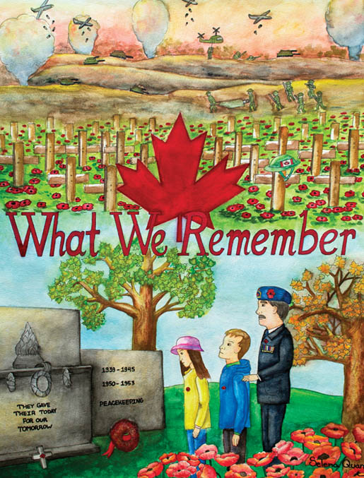
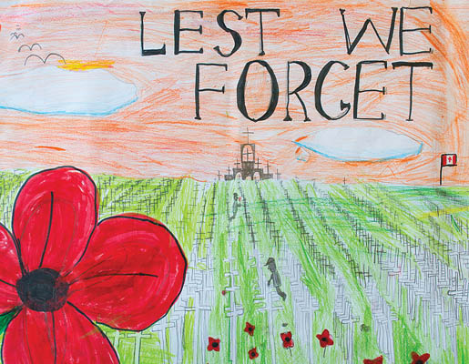
Winning junior poster by Selena Quang of Nepean, Ont.
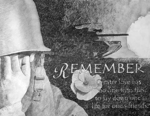
Winning poster by Joseph Brink of Brampton, Ont.
Winning primary poster by Patrick Piao of Orillia, Ont.
Winning primary poster by William Brink of Brampton, Ont.
SENIOR
COLOUR POSTER—First: Natasha Jones, North Vancouver, B.C.; Second: Anna Kumpan, North Wiltshire, P.E.I.; Honourable Mention: Strong Duan, Calgary.
BLACK AND WHITE POSTER—First: Sideqa Haqani, Gloucester, Ont.; Second: Adam Werkman, Winnipeg; Honourable Mention: Keisha Collins, Hare Bay, N.L.
POEM—First: Inés Carolina Fiedler, Windsor, Ont.; Second: Andrea Bell, Chaplin Island Road, N.B.; Honourable Mention: Samantha Ryan, Bonavista, N.L.
ESSAY—First: Victoria Fisher, Minnedosa, Man.; Second: Chance Michael Fiessel, Sturgeon County, Alta.; Honourable Mention: Sutherland Greer, Indian Brook, N.S.
INTERMEDIATE
COLOUR POSTER—First: Madison Luney, Burnaby, B.C.; Second: Dane Fichter, Strasbourg, Sask.; Honourable Mention: Rehanna Othman, Wyevale, Ont.
BLACK AND WHITE POSTER—First: Caitlyn Mei, Richmond Hill, Ont.; Second Anna Fullerton, Truro, N.S.; Honourable Mention: Radhika Verma, Stephenville, N.L.
POEM—First: Caleb Marcella, Stokes Bay, Ont.; Second: Kianah Howk, Cochrane, Alta.; Honourable Mention: Mackenzie Alyssa Silliker, Lyttleton, N.B.
ESSAY—First: Morgan Svenkeson, Kinistino, Sask.; Second: Katia Hughes, Charlottetown; Honourable Mention: Urooj Salar, Winnipeg.
JUNIOR
COLOUR POSTER—First: Selena Quang, Nepean, Ont.; Second: Anna Salamone, Rothesay, N.B.; Honourable Mention: Rebecca Duncan, Estevan, Sask.
BLACK AND WHITE POSTER—First: Joseph Brink, Brampton, Ont.; Second: MeiLin Li, Calgary; Honourable Mention: Emily Zbaraschuk, Paddockwood, Sask.
POEM—First: Adrian Van Gorkom, Powell River, B.C.; Second: Matthew Wang, Charlottetown; Honourable Mention: Lee Kelly, Parrsboro, N.S.
ESSAY—First: Emma Lunau-Smith, Guelph, Ont.; Second: Natalie Chisholm, Enfield, N.S.; Honourable Mention: Maia Zinselmeyer, Nakusp, B.C.
PRIMARY
COLOUR POSTER—First: Patrick Piao, Orillia, Ont.; Second: Amber Bartley, Ponoka, Alta.; Honourable Mention: Harry Burke, Souris, P.E.I.
BLACK AND WHITE POSTER—First: William Brink, Brampton, Ont.; Second: Addyson Boylak, Wynyard, Sask.; Honourable Mention Titus Stahl, Camrose, Alta.
First Place Senior Essay
“Boys in the sand”
by Victoria Fisher
A curtain shifts as the bus makes a turn, allowing a shaft of bright sun to attack my face and render me blind. Tears build in my eyes as I squint into the glare but I make no move to wipe them away. It’s useless, I think, to bother when I know that these tears will be only some of the many shed today.
It’s June 5, 2014. I am travelling to Juno Beach, location of the infamous D-Day landings. Seventy years ago today, thousands of Canadian men, some barely older than myself, journeyed to the same place. However, the difference between those soldiers and me is that I know I will return home. On June 6, 1944, some 14,000 men (and boys) from our country stormed the beaches of France in an attempt to end Hitler’s reign of terror. Under such circumstances, who would have thought that today I would shed tears of joy.
The bus makes a final turn, and I’m roused from my thoughts by the rumbling of tires on gravel. My feet meet dusty ground and my feelings are mixed as I walk the path leading to the museum. Soft puffs of cloud dapple the azure sky, allowing light to sparkle off the ocean and highlight the soft hues of wildflowers peeking from the tall grass. Full of France’s lush beauty, it’s hard to imagine this place as a deadly battlefield. The Juno Beach Centre appears in front of us, a contrasting collage of modern and historic times. Beside the museum sits, a proudly waving Canadian flag. An equally grand French flag flies by its side. Hundreds of plaques adorn giant concrete pillars, thanking those who sponsored the centre.
It is heartwarming to see such teamwork, but I bitterly wish that there were no reason to build this place, no Canadian deaths to mourn. It is when we approach the grassy outcrop overlooking the beach that hints of war begin to show. The entrances to German bunkers gape, like open mouths, in the sand. Around them sit huge cement pyramids that used to hold back tanks. The sand is pale and soft beneath my feet, but I grimly wonder how much blood left it clumped and stained in the past.
Why must we fight such brutal wars? As my eyes comb the strange marks inside the bunker, I suddenly feel sick. I avert my eyes and hurry back to the surface. I continue to the beach. The sand becomes thicker under my feet as the grass thins, and attracts my gaze as I stop to think. I try to imagine what this place must have looked like in the midst of war. I picture boat after boat closing in on the shore, then soldier after soldier sprinting for cover on the wet sand. I think of the rattle of gunfire and the scars left by tanks in the earth, the smell of smoke and the sounds of screams carried on the wind. It is hard to imagine though, for I have never known war.
I’m finishing this thought as a sharp cry sounds behind me. Its high pitch is that of a young child. I turn in time to see them tumble onto the beach, two French boys, no more than four years old. Their father trails behind, watching affectionately as they laugh and roll in the sand. At first I feel a prick of anger. Who lets their child yell and wrestle on such hallowed ground? As I watch, however, I remember that they’re still young. Four-year-olds aren’t expected to understand war. Suddenly I’m hit with a wave of thankfulness. There was a time not so long ago that a four-year-old boy would be expected to understand war; a time when worldwide fighting wasn’t a chapter in a history book but a way of life.
Those boys and I have a lot in common. We both grew up in such a peaceful environment that we don’t know the horrors of battle. I can read about it in books, but I didn’t experience the death and oppression firsthand. Those thousands of men died for the future, the idea that their children could grow up the way I am now. A bittersweet tear builds in my eye when I think of this. I grieve for those who came before me and gave everything, 70 years ago, on the hope that they could make things better.
I also feel joy and gratefulness. They dedicated themselves fully to the battle against oppression and they succeeded. They succeeded for the future, and for me. I only hope that if my time comes to take a stand that I can do it too, for those like the boys in the sand.
Advertisement